
Atlas Gerardi Mercatoris, Jodocus Hondius
Collection of early maps from various sources by BibliOdyssey.
")
City map of Venice - Liber Chronicarum (p. 272)
Collection of early maps from various sources by BibliOdyssey.

Konrad von Grünenberg - Beschreibung der Reise von Konstanz nach Jerus...
Collection of early maps from various sources by BibliOdyssey.
 (artist unknown)")
Podroban nacrt Beograda i tvrdave (1710-1720) (artist unknown)
Collection of early maps from various sources by BibliOdyssey.
")
Southern Circumpolar Map (Burritt, 1833)
Collection of early maps from various sources by BibliOdyssey.
. Redigee par A. Brue a")
Carte de l'Australie, (partie sud-ouest de l'Oceanie). Redigee par A. ...
Collection of early maps from various sources by BibliOdyssey.
, 1793")
Geography Bewitched or a droll caricature map of England and Wales (af...
Collection of early maps from various sources by BibliOdyssey. Public domain reproduction of political cartoon, free to use, no copyright restrictions image - Picryl description

Konrad von Grünenberg - Beschreibung der Reise von Konstanz nach Jerus...
Collection of early maps from various sources by BibliOdyssey.

Marion + Linn Counties, Oregon - Public domain old map
Collection of early maps from various sources by BibliOdyssey.

Wageningen map - Public domain vintage map
Collection of early maps from various sources by BibliOdyssey. Public domain scan of architectural plan, map, free to use, no copyright restrictions image - Picryl description

The Raymer Map of Oklahoma - Public domain map
Collection of early maps from various sources by BibliOdyssey.

Visscher 1690 - Public domain vintage map
Collection of early maps from various sources by BibliOdyssey.

The Earth: its Form and Position in Space
Collection of natural science, astronomy and ancient technology images from various sources selected by BibliOdyssey.

Atlas Novus Terrarum Orbis Imperia - Public domain map
Collection of early maps from various sources by BibliOdyssey.
")
Beograd - pogled sa ugarske strane, 1700-1710 (artist uknown)
Collection of early maps from various sources by BibliOdyssey.

Campus Martius 1762 by G Piranesi - Public domain map
Collection of early maps from various sources by BibliOdyssey. Public domain scan of architectural plan, map, free to use, no copyright restrictions image - Picryl description

Carl Johan Gethe n - Public domain vintage map
Collection of early maps from various sources by BibliOdyssey.

Grolla - Public domain vintage geogrpaphic map
Collection of early maps from various sources by BibliOdyssey. Public domain scan of architectural plan, map, free to use, no copyright restrictions image - Picryl description

Zarra, Italy - A drawing of a castle on a small island
Collection of early maps from various sources by BibliOdyssey.

A General Atlas, Of All The Known Countries In The World 1822
Collection of early maps from various sources by BibliOdyssey.
 c")
Atlas zu Alex. v. Humboldt's Kosmos in zweiundvierzig.. (botanicus) c
Collection of early maps from various sources by BibliOdyssey.

Britain at the time of the Saxon Heptarchy - John Speed proof maps 160...
Collection of early maps from various sources by BibliOdyssey.
")
Islandia 1609 Abraham Ortelius (raremaps.com)
Collection of early maps from various sources by BibliOdyssey.
 - Public domain vintage map")
Japan (Dejima Island) - Public domain vintage map
Collection of early maps from various sources by BibliOdyssey.

Nolin map 176 - Public domain vintage map
Collection of early maps from various sources by BibliOdyssey.

Mechilina vulgo Malinis - map, Netherlands
Collection of early maps from various sources by BibliOdyssey. Public domain scan of architectural plan, map, free to use, no copyright restrictions image - Picryl description

Plan général du château et jardins de Marly
Collection of early maps from various sources by BibliOdyssey. Public domain scan of settlement or building architecture plan, free to use, no copyright restrictions image - Picryl description
 1653")
Spiritual Use of an Orchard Garden of Fruit Trees (titlepage) 1653
Collection of early maps from various sources by BibliOdyssey.
 - Public domain old map")
Sri Lanka map (Ceylon - 1751) - Public domain old map
Collection of early maps from various sources by BibliOdyssey.
 1820-1829")
Tableau comparatif des principales montagnes, des principaux fleuves (...
Collection of early maps from various sources by BibliOdyssey.

The Royal Illustrated Atlas, Of Modern Geography 1872
Collection of early maps from various sources by BibliOdyssey.
 - Public domain map")
Amérique du Nord (pub. by Logerot) - Public domain map
Collection of early maps from various sources by BibliOdyssey.
 - Public domain map")
Amerique du Sud (pub. by Logerot) - Public domain map
Collection of early maps from various sources by BibliOdyssey.

Bird's eye panorama of Manhattan & New York City in 1873
Collection of early maps from various sources by BibliOdyssey.
")
Geological Map of the State of Pennsylvania 1858 (detail)
Collection of early maps from various sources by BibliOdyssey.

Konrad von Grünenberg - Beschreibung der Reise von Konstanz nach Jerus...
Collection of early maps from various sources by BibliOdyssey.

Petit atlas moderne ou collection de cartes elementaires dedie a la je...
Collection of early maps from various sources by BibliOdyssey.

State, Territorial and Ocean Guide Book of the Pacific 1866
Collection of early maps from various sources by BibliOdyssey.

Sydney Cove 1808 - Public domain vintage map
Collection of early maps from various sources by BibliOdyssey.
")
Topographic Atlast of the City of New York, 1874 (reduced)
Collection of early maps from various sources by BibliOdyssey.
")
Walker's New Geographical Game Exhibiting a Tour Through Europe (vam.a...
Collection of early maps from various sources by BibliOdyssey.
, 1854")
Comparative Geography (mountains + rivers), 1854
Collection of natural science, astronomy and ancient technology images from various sources selected by BibliOdyssey.

A plain map or emblematic chart for the geographical game of Europe, a...
Collection of early maps from various sources by BibliOdyssey.

Angling in troubled waters, 1899 - Public domain old map
Collection of early maps from various sources by BibliOdyssey.

Daviess County, Kentucky - Public domain vintage map
Collection of early maps from various sources by BibliOdyssey.

Description of the Holy Land - Public domain old map
Collection of early maps from various sources by BibliOdyssey.
 1835 a")
Distribution of Vegatables and Snow Line + Comparative Lengths of Rive...
Collection of early maps from various sources by BibliOdyssey.

Includes large vignette with the tools of cartographers and surveyors ...
Collection of early maps from various sources by BibliOdyssey.

La récréation Européenne ou jeu des princes de l'Europe
Collection of early maps from various sources by BibliOdyssey.

The West-India atlas or, a compendious description of the West Indies ...
Collection of early maps from various sources by BibliOdyssey.
 1832")
A comparative view of the lengths of the principal rivers of Scotland ...
Collection of early maps from various sources by BibliOdyssey.

Clemen's Silent Teacher - Dissected map of the United States
Collection of early maps from various sources by BibliOdyssey.

Geographie moderne avec une introduction 1787
Collection of early maps from various sources by BibliOdyssey.

Konrad von Grünenberg - Beschreibung der Reise von Konstanz nach Jerus...
Collection of early maps from various sources by BibliOdyssey.

Peruvian Bitters - Bird's Eye View of San Francisco, 1880s
Collection of early maps from various sources by BibliOdyssey.

St John City and County, New Brunswick, Canada
Collection of early maps from various sources by BibliOdyssey.
 1832")
A comparative view of the heights of the principal mountains of Scotla...
Collection of early maps from various sources by BibliOdyssey.

Aethiopia - Public domain vintage map
Collection of early maps from various sources by BibliOdyssey.

An illustrated historical atlas of the State of Minnesota 1874
Collection of early maps from various sources by BibliOdyssey.

A.T. Andreas' illustrated historical atlas of the State of Iowa 1875
Collection of early maps from various sources by BibliOdyssey.

L'Europe animale - physiologie comique, 1882
Collection of early maps from various sources by BibliOdyssey.

Mexico - Public domain vintage geogrpaphic map
Collection of early maps from various sources by BibliOdyssey.

Harderwiik - Public domain vintage map
Collection of early maps from various sources by BibliOdyssey. Public domain scan of architectural plan, map, free to use, no copyright restrictions image - Picryl description

Tyel - Public domain old vintage map
Collection of early maps from various sources by BibliOdyssey. Public domain scan of architectural plan, map, free to use, no copyright restrictions image - Picryl description

Ptolemy Cosmographia 1467 - world map
Collection of early maps from various sources by BibliOdyssey. Public domain reproduction of Greek Byzantine medieval illuminated manuscript page, free to use, no copyright restrictions image - Picryl description

Image from BibliOdyssey collection - Public domain map
German WWI map. Collection of early maps from various sources by BibliOdyssey.

Stampalia, Italy, Greece
Collection of early maps from various sources by BibliOdyssey. Public domain scan of a map, free to use, no copyright restrictions image - Picryl description
")
Vesuvius Lava map (John Auldjo, 1832)
Collection of early maps from various sources by BibliOdyssey.

Whiteside County, Illinois - Public domain old map
Collection of early maps from various sources by BibliOdyssey.

A Journey Through Europe or the Play of Geography
Collection of early maps from various sources by BibliOdyssey.

A New Map of India from the Latest Authority p9
Collection of early maps from various sources by BibliOdyssey. Public domain photograph of political cartoon, free to use, no copyright restrictions image - Picryl description

Bridgens' Atlas Of Lancaster Co., Penna 1864
Collection of early maps from various sources by BibliOdyssey.

Das heutige Europa, 1875 - Public domain vintage map
Collection of early maps from various sources by BibliOdyssey.

Homan 1718 - Public domain vintage map
Collection of early maps from various sources by BibliOdyssey.

David Loggan - Hortus Botanicus - Public domain old map
Collection of early maps from various sources by BibliOdyssey. Public domain scan of architectural plan, map, free to use, no copyright restrictions image - Picryl description

Europe in 1914 map - Public domain geographic map
Collection of early maps from various sources by BibliOdyssey.

Napoli de Romania - Public domain vintage map
Collection of early maps from various sources by BibliOdyssey.

Santa Clara County, California - Public domain old map
Collection of early maps from various sources by BibliOdyssey.

Constellations of the Northern Hemisphere
Collection of natural science, astronomy and ancient technology images from various sources selected by BibliOdyssey.

A New General Atlas comprising a complete set of maps representing the...
Collection of early maps from various sources by BibliOdyssey.

Atlas fisico y politico de la Republica de Venezuela 1840
Collection of early maps from various sources by BibliOdyssey.

Bird's eye view of New-York & Brooklyn a
Collection of early maps from various sources by BibliOdyssey. Public domain photograph of painting, 19th century, free to use, no copyright restrictions image - Picryl description

Britannia by James Gillray, 1791 - Public domain old map
Collection of early maps from various sources by BibliOdyssey.

City of New York - sketched and drawn on stone by C. Parsons.
Collection of early maps from various sources by BibliOdyssey.

Hampshire - Isle of Wight, England -- John Speed proof maps 1605-1610
Collection of early maps from various sources by BibliOdyssey.
 1846")
Heights Of The Principal Mountains In The World (Mitchell) 1846
Collection of early maps from various sources by BibliOdyssey.

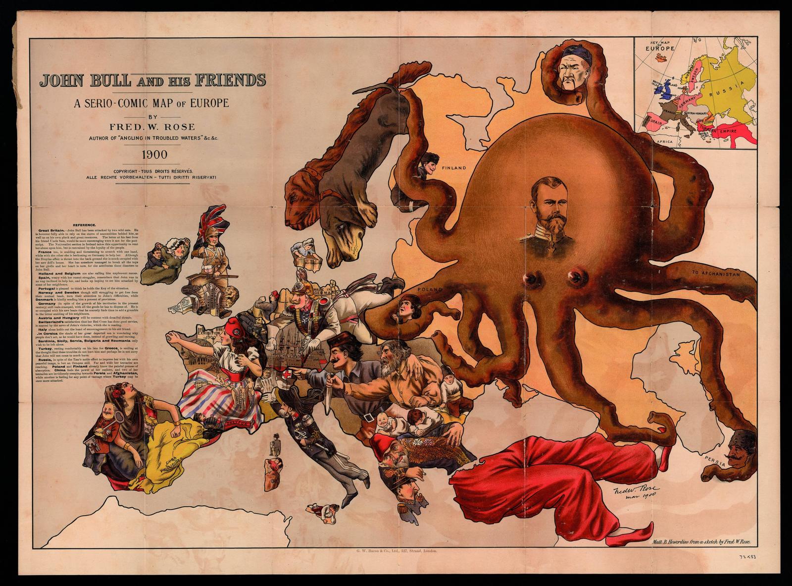
John Bull and his Friends by Fred W Rose, 1900
Collection of early maps from various sources by BibliOdyssey.

Projet pour un nouveau château de Compiègne, 1729
Collection of early maps from various sources by BibliOdyssey.

Scardona, Italy - A map of a town with a river running through it
Collection of early maps from various sources by BibliOdyssey. Public domain photograph of renaissance Italian art, free to use, no copyright restrictions image - Picryl description

Theatrum Orbis Terrarum, Abraham Ortelius
Collection of early maps from various sources by BibliOdyssey. Public domain reproduction of illuminated manuscript page, 16th century, free to use, no copyright restrictions image - Picryl description Public... More
")
A Partial View of London and the Environs 1813 (Villanova U)
Collection of early maps from various sources by BibliOdyssey.

An Illustrated Atlas, Geographical, Statistical, And Historical, Of Th...
Collection of early maps from various sources by BibliOdyssey.
")
Atlas zu Alex. v. Humboldt's Kosmos in zweiundvierzig.. (botanicus)
Collection of early maps from various sources by BibliOdyssey.

Romeyn de Hooghe - Biblia by Romeyn de Hooghe, 1682
Collection of early maps from various sources by BibliOdyssey.

Hamilton County, Ohio - Public domain vintage map
Collection of early maps from various sources by BibliOdyssey.

Europe wwi humor map. Humoristische-oorlogskaart, 1870
Collection of early maps from various sources by BibliOdyssey. Public domain reproduction of political cartoon, free to use, no copyright restrictions image - Picryl description

Le Jeu de France - Public domain dedication image
Collection of early maps from various sources by BibliOdyssey. Public domain image related to board games, free to use, no copyright restrictions image - Picryl description

Oxfordshire, England - John Speed proof maps 1605-1610
Collection of early maps from various sources by BibliOdyssey.

Liege, Netherlands map - A map of a city with a river running through ...
Collection of early maps from various sources by BibliOdyssey. Public domain scan of a plan of settlement buildings, free to use, no copyright restrictions image - Picryl description
")
Rambles Through Our Country - An Instructive Geographical Game for the...
Collection of early maps from various sources by BibliOdyssey.